Page 2 of 3
Re: Offaly GAA Club Map and Population Estimates
Posted: Mon Sep 07, 2026 12:35 pm
by Hit and Miss
Plain of the Herbs wrote: ↑Sun Sep 06, 2026 11:28 pm
The Ballyskenagh team that played the 2003 County Final. All look local names to me. They were:
Tomás O’Toole; Eugene Hannon, Cathal Murphy, Brendan Franks; Mark Kirwan, Mick O’Hara, David Franks; Barry Keeshan, Alan Middleton; Brendan Murphy, Noel Murphy, Eoghan Franks; Aidan Franks, David Carney, John Dooley. Sub used: Derek Middleton.
Arguably a greater achievement was Ballskenagh winning the Minor A hurling championship on their own in 1991.
SearingDrive wrote: ↑Sun Sep 06, 2026 10:39 pm
Hit and Miss wrote: ↑Sat Sep 05, 2026 6:23 pm
Very well put together , well done !
Will definetly be helpfull for someone .
Does anyone have any detail on Ballyskenagh county final around that final time ?
Any Tipp / Shinrone players etc ?
Its amazing to see so many players outside of their borders where it is generally accepted but then you have the trials and tribulations of Tullamore/Cappincur.
Wonder would a gaa membership figure relative to the area be a next step ?
I think it was the 2003 SHC Final v Birr. There were a lot of players called Franks, and Kirwan. All were from Offaly. Interestingly, Ballyskenach is in Roscrea parish, and they originally played in North Tipperary championship. Around 1960, a decision was made by Tipp.GAA, that there should be just one team in the parish.
Ballyskenach had a choice to make, and they successfully applied to play in the Offaly hurling championship. POTH confirmed this to me, as I had an idea BSch, originally played in Tipperary at junior level.
Well known inter county referee Gerry Kirwan, from the 60’s and 70’s was from the Ballyskenach club.
Ah yes , the Frank's / Hannons were in my head as being borderline Shinrone but I didnt know how far that boundary came up that way. Was under the impression Ballyskenagh was nearer Roscrea too , like Shamrocks and Tullamore . Great to have a visual now and hopefully more can add fact to it.
Was always a bit of a wonder how far Coolderry came over the main road.
Re: Offaly GAA Club Map and Population Estimates
Posted: Tue Sep 08, 2026 7:41 pm
by True Red
This is a marvellous resource.
Fair play
Re: Offaly GAA Club Map and Population Estimates
Posted: Wed Sep 09, 2026 10:29 am
by theman
Well done on completing this resource. A very well put together Map, and I am sure there was countless hours involved, so hats off for compiling all this.
Not to be pedantic, but as a Clonbullogue man, I must point out the border with our neighbours

The border of Clonbullogue is slightly inaccurate. At the bottom "dog leg" along the R442, Clonbullogue takes in the townlands of Clonmore and Cloncassan.
I have attached a screenshot to show a rough idea of the border. It goes out as far as the Figile river on the East side, and splits somewhere on the West as highlighted. Comes down down just 200m before the crossroads on the R442 heading into Bracknagh village, before the Figile river crossing. There is a stream here that is the broder, but it's not shown on google maps.
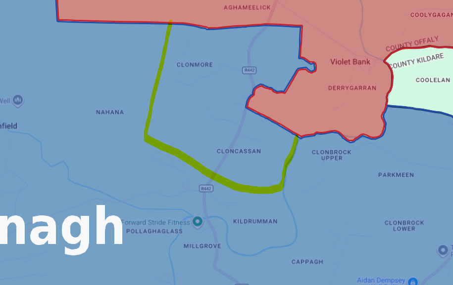
- Clon_Brack Border.png (139.83 KiB) Viewed 1830 times
Again, well done on putting this together. It's amazing to see the size of some clubs - some larger than I originally thought, and some smaller than originally perceived.
Re: Offaly GAA Club Map and Population Estimates
Posted: Wed Sep 09, 2026 3:32 pm
by ryot
Brilliant work. Nice to be able to see at a glance where every club is. Being from North West of the county I would not have know some of the east county clubs.
A few issued with the Doon area.
Clongawny, home of Aaron & Christian Brazil is in Clonmacnoise Parish and is Shannonbridge GAA territory.
Cappanalosset is and has always been Ballycumber territory (Pius & Bosco Larkin and Derrek Claffey ).
While Straduff (Big Hughie Egan) and Thumbeagh (Andrew & Kieran Egan) are Doon, seperated from Erins Rovers by a massive bog and road connection would via Ferbane of via Boher !!! I'm not sure if you have placed them in Doon or not !!!
There would be a few cross-overs, such as lads from Esker (Offaly) going to NS in Castledaly (Westmeath) and playing for Castleday & even Westmeath while at the other end some from Clonascra go to NS in Clonmacnoise ( half a mile rather than 3/4 miles to Ballinahown) and play with Shannonbridge but some do join Doon !!!!
Re: Offaly GAA Club Map and Population Estimates
Posted: Wed Sep 09, 2026 8:07 pm
by ryot
Kilnagoolny alongside Thumbeagh is also Doon not Erin/s Rovers.
Re: Offaly GAA Club Map and Population Estimates
Posted: Thu Sep 10, 2026 9:55 am
by The Magpie
A great piece of work that represents proper research, which seems pretty rare these days.
As the (known) accuracy of the boundaries improves with fantastic work like this, I'd like to know how things really play out from club to club. Although it may be harder to prove over the entire history of a club, I'd still be interested to know whether there are present-day, accepted, known anomalies to what is shown in the map.
For example, I can't ever remember people from Horseleap (or close) playing Gaelic games with Clara. I suspect most are drawn to Tubber. And I don't believe Clara protest against such? Perhaps that supports offalyclubmaps assertion that "Parish Rule" is something that we talk about more than enforce.
Also, SuperHans requested a breakdown of ages across Parishes shown in the map. It would be great to see other demographic variables (from Census) as an optional overlay on the map.
Probably the antithesis to your efforts, I had a quick look on ChatGpt and an overlay looks pretty feasible. We’d probably need the KMZ file though.
Re: Offaly GAA Club Map and Population Estimates
Posted: Fri Sep 11, 2026 10:03 am
by OffalyBlue
Hi Offalyclubmap,
Fair play to you. There is great detail, time and effort put into your work.
The map for Erin Rovers is wrong. It is not as big as your map has showing and in turn the population they have to pick from will be wrong also.
The map should stop just before "Rigney Plaster mouldings", - there is a brooke there and that is the boundary. Everyone from there up to Lemanaghan play with Ballycumber. Some families before the brooke, would even have played with Ballycumber also. I believe that some families who lived close to Lemanaghan use to play with Erin Rovers back in the day and there was a fall out and they left and went to Ballycumber.
When you turn up the Dernagun road to Ballycumber, all families play with Ballycumber.
On the L6027 road at Oughter, at the head of that road when you turn left they play with Shamrocks, turn right there is a brooke a few hundred yards, after the brooke they play with Ferbane.
The road to Turraun, they families there play with Erin Rovers.
Re: Offaly GAA Club Map and Population Estimates
Posted: Sat Sep 12, 2026 12:00 pm
by Hit and Miss
Can anyone posting opposing boundaries provide evidence to prove so as opposed to local knowledge ?
Not about right or wrong or that the local knowledge is incorrect.
Just such an interesting thing that road X is always associated with club Y but factually is not corresponding to that area.
I think any input is welcome but the original poster is looking for evidence to adjust the map accordingly and I think that can get lost here very easily.
The potential for this to be a factual resource is massive. Fascinating to see this again in 6 months time plus
Re: Offaly GAA Club Map and Population Estimates
Posted: Sat Sep 12, 2026 12:45 pm
by Plain of the Herbs
Thing is that boundaries between parishes are clearly defined. But boundaries between clubs within the same parish - such as Leamonaghan, Daingean and Clonbullogue - aren't going to be marked on an official map. They are probably based on old gentlemans' agreements that have survived through the generations. Id say offalyclubmap would welcome local input.
Re: Offaly GAA Club Map and Population Estimates
Posted: Sat Sep 12, 2026 1:47 pm
by offalyclubmap
The Magpie wrote: ↑Thu Sep 10, 2026 9:55 am
A great piece of work that represents proper research, which seems pretty rare these days.
As the (known) accuracy of the boundaries improves with fantastic work like this, I'd like to know how things really play out from club to club. Although it may be harder to prove over the entire history of a club, I'd still be interested to know whether there are present-day, accepted, known anomalies to what is shown in the map.
For example, I can't ever remember people from Horseleap (or close) playing Gaelic games with Clara. I suspect most are drawn to Tubber. And I don't believe Clara protest against such? Perhaps that supports offalyclubmaps assertion that "Parish Rule" is something that we talk about more than enforce.
Also, SuperHans requested a breakdown of ages across Parishes shown in the map. It would be great to see other demographic variables (from Census) as an optional overlay on the map.
Probably the antithesis to your efforts, I had a quick look on ChatGpt and an overlay looks pretty feasible. We’d probably need the KMZ file though.
Thank you for the kind words.
Interesting regarding your personal experience with Horseleap.
For the map, Horseleap is covered by Clara GAA, not Tubber, for the Offaly-side catchment. I've looked into this again and can't find any firm evidence of Horseleap being covered by Tubber.
The strongest evidence is the present Catholic parish itself: St Brigid’s Parish explicitly states that it covers Clara and Horseleap. Under Offaly GAA’s parish-based catchment rule, those Horseleap townlands within County Offaly therefore belong in the Clara polygon.
Like so much of this - there may be a formal local arrangement between Tubber and Clara GAA which isn't published anywhere or, more likely, maybe a blind eye is thrown when people form Horseleap play for Tubber.
If anybody has any evidence of anything formal, I'd love to have it.
Re: Offaly GAA Club Map and Population Estimates
Posted: Sat Sep 12, 2026 2:25 pm
by Kevin
Thank you OCM. It helps bring context to many of the discussions.on here.
Much appreciated.
Re: Offaly GAA Club Map and Population Estimates
Posted: Sat Sep 12, 2026 7:23 pm
by Hit and Miss
Plain of the Herbs wrote: ↑Sat Sep 12, 2026 12:45 pm
Thing is that boundaries between parishes are clearly defined. But boundaries between clubs within the same parish - such as Leamonaghan, Daingean and Clonbullogue - aren't going to be marked on an official map. They are probably based on old gentlemans' agreements that have survived through the generations. Id say offalyclubmap would welcome local input.
Yes definitely agree , the more local input the more chance of factual accuracy.
Even based on old gentlemans agreements etc they are a set boundary and not something fluid. The variance between that and official parish boundary has to be fascinating for all to actually see defined on a map.
Hope this continues to gain traction for you OCM.
Im sure there are lots here with valuable information to contribute.
Re: Offaly GAA Club Map and Population Estimates
Posted: Mon Sep 14, 2026 10:34 am
by theman
Hit and Miss wrote: ↑Sat Sep 12, 2026 12:00 pm
Can anyone posting opposing boundaries provide evidence to prove so as opposed to local knowledge ?
Not about right or wrong or that the local knowledge is incorrect.
Just such an interesting thing that road X is always associated with club Y but factually is not corresponding to that area.
I think any input is welcome but the original poster is looking for evidence to adjust the map accordingly and I think that can get lost here very easily.
The potential for this to be a factual resource is massive. Fascinating to see this again in 6 months time plus
That is a very fair point Hit and Miss.
From the Clonbullogue/Bracknagh point the argument can be backed up by the postal addresses on the road. All houses either side of the R442 will have Clonbullogue addresses, up the point of the crossing of the water course 200m up from the crossroads before the Figile. The first house the other side of the water crossing on the Bracknagh side has a Bracknagh address, and every house after that leading up the village of Bracknagh - these can all be validated by Eircode checker online.
Great debate being had on here, so fair play offalyclubmap for getting this topic started. Be interesting to see it in years to come.
Re: Offaly GAA Club Map and Population Estimates
Posted: Wed Sep 16, 2026 3:24 pm
by offalyclubmap
theman wrote: ↑Mon Sep 14, 2026 10:34 am
Hit and Miss wrote: ↑Sat Sep 12, 2026 12:00 pm
Can anyone posting opposing boundaries provide evidence to prove so as opposed to local knowledge ?
Not about right or wrong or that the local knowledge is incorrect.
Just such an interesting thing that road X is always associated with club Y but factually is not corresponding to that area.
I think any input is welcome but the original poster is looking for evidence to adjust the map accordingly and I think that can get lost here very easily.
The potential for this to be a factual resource is massive. Fascinating to see this again in 6 months time plus
That is a very fair point Hit and Miss.
From the Clonbullogue/Bracknagh point the argument can be backed up by the postal addresses on the road. All houses either side of the R442 will have Clonbullogue addresses, up the point of the crossing of the water course 200m up from the crossroads before the Figile. The first house the other side of the water crossing on the Bracknagh side has a Bracknagh address, and every house after that leading up the village of Bracknagh - these can all be validated by Eircode checker online.
Great debate being had on here, so fair play offalyclubmap for getting this topic started. Be interesting to see it in years to come.
Thank you very much for the feedback. I've researched this extensively and its plausible without being confirmed. There is nothing formally online as to the border between the clubs. Those areas do have Clonbullogue Eircodes but are in the bracknagh elcectoral district. Its enough however to change the map and population totals, which I have done.
As always, if anybody has any formal information, I would love to have it.
Re: Offaly GAA Club Map and Population Estimates
Posted: Wed Sep 16, 2026 3:35 pm
by offalyclubmap
ryot wrote: ↑Wed Sep 09, 2026 8:07 pm
Kilnagoolny alongside Thumbeagh is also Doon not Erin/s Rovers.
Thank you. Researched and accepted. Map changed.